![]()
Sponsored By
ROCK
HARDWARE
Meredith Areas [ Guide | Images ] |
|
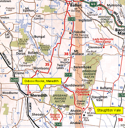
Below: A map of the area surrounding Meredith. To reach Oxbow Rocks, drive to Meredith, then depart the township at the north end, where you'll find the road to Durdidwarrah hiding just off the Ballan road. Cruise down the Durdidwarrah road for 5 kms or so, until you reach the bridge across the Moorabool River. Park on the opposite side, but return to the Meredith side and hike downstream.
| Zoom Out | |
|
|
|
|
Copyright Melway
Publishing 2002. Reproduced from Melway Edition 28 with permission. |
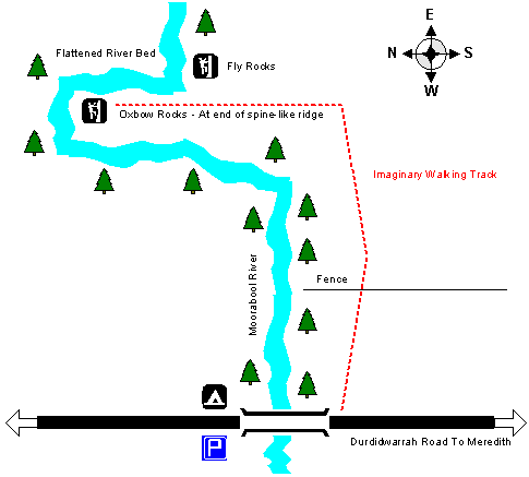
The following diagram shows how to reach Oxbow and
Fly Rocks at the Meredith climbing location. You'll find the bridge about
5kms out of Meredith on the Durdidwarrah road. The walking track does not
exist, you'll have to go bush. Note the Oxbow Rocks cliff is not visible
until you are standing directly below it. Avoid the nasty scrub near the
river by walking downstream of the bridge high up on the river bank for
about 15 minutes, until you sight the spine-like ridge leading left. Oxbow
Rocks is at it's end.
Home | Guide | Gallery | Tech Tips | Articles | Reviews | Dictionary | Forum | Links | About | Search
Chockstone Photography | Landscape Photography Australia | Australian Landscape Photography
Please read the full disclaimer before using any information contained on these pages.
All text, images and video on this site are copyright. Unauthorised use is strictly prohibited.