![]()
Cathedral Range, Buxton [ Guide ] |
|
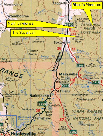
Below: A map of Cathedral Range and surrounds. The Cathedral Range is a good hour and a half drive from Melbourne. Get free of the city and head north-east to Healesville. From here a slow but scenic forest drive takes you to Buxton. For the sugarloaf area, nip down the road towards Marysville for 4km and take a left onto Mt Margaret road. Fire up this, forking left at 3km, and striking the Sugarloaf day visitors hut after another 5km of winding dirt road. If you continue another 5km more you'll get to the North Jawbones car park. An alternative access for North Jawbones is to take the Cathedral Lane turn off 9km out of Buxton (heading for Alexandra), then the Cathedral State Park turn off 3km away, before finding the Cooks Mill camping ground 5km further on. Drive another 500m or so to find the North Jawbones car park on your right.
| Copyright Melway
Publishing 2002. Reproduced from Melway Edition 28 with permission. |
Home | Guide | Gallery | Tech Tips | Articles | Reviews | Dictionary | Forum | Links | About | Search
Chockstone Photography | Landscape Photography Australia | Australian Landscape Photography
Please read the full disclaimer before using any information contained on these pages.
All text, images and video on this site are copyright. Unauthorised use is strictly prohibited.