![]()
Sponsored By
ROCK
HARDWARE
Chockstone Photography
Australian Landscape Prints |
 Chockstone Forum - Crag & Route Beta
Crag & Route Beta
| Area | Location | Sub Location | Crag | Links |
| VIC Grampians | (General) | (General) | (General) | [ Grampians Guide | Images ] |
| Author |
|
|||||
1:43:18 PM |
Keiran, do you think the bolts will need replacing on the Wall of Fools? | |||||
1:58:09 PM |
On 24/01/2014 jdb wrote: >Keiran, do you think the bolts will need replacing on the Wall of Fools? I'd be surprised. I'm not aware of that being necessary at other cliffs after fires, except where the bolts were rubbish to start with. That said, I'm no engineer. |
|||||
4:03:00 PM |
On 24/01/2014 kieranl wrote: >On 24/01/2014 jdb wrote: >>Keiran, do you think the bolts will need replacing on the Wall of Fools? >I'd be surprised. I'm not aware of that being necessary at other cliffs >after fires, except where the bolts were rubbish to start with. That said, >I'm no engineer. The bolts probably won't need replacing in the short-term, but they are certainly more likely to require replacing a bit earlier... Durability of bolts, fastening method and the rock itself can all be variably affected by the peak temperatures of a bush fire. |
|||||
4:56:13 PM |
It would be worth someone consulting their glue manufacturer, though the answer would probably be CYA. | |||||
6:39:46 PM |
I've seen a look of fires over the years and not once have I seen problems with bolts. | |||||
5:28:48 PM |
http://m.earthobservatory.nasa.gov/NaturalHazards/view.php?id=82934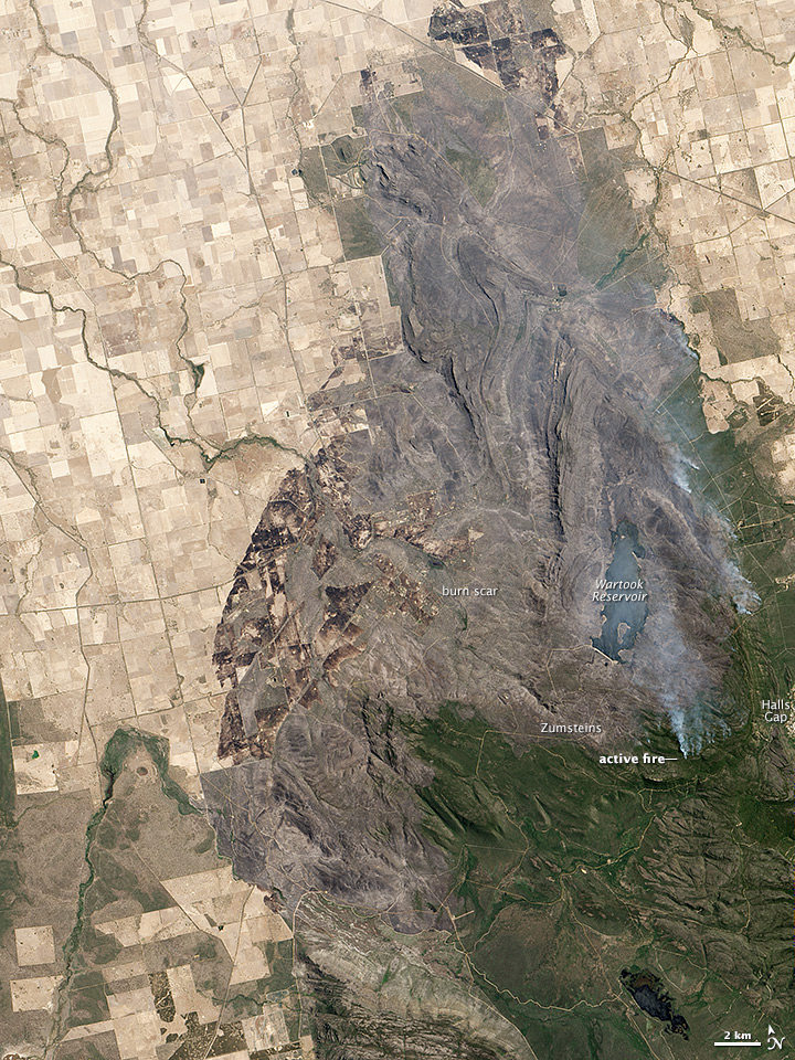
|
|||||
7:45:31 PM |
Wow. Even though I've seen the map of the fire area, this just brings the thing home. Another thing to note is the northern vic range and the difference between the slopes above the Emu's Foot tracks where Eureka Walls and Weirs are, and the Muline and Buandik areas. The only green bit is the delta where Weirs Creek spreads out onto the floodplain. This is 11 months after the fire and the slopes are still bare. This is why this part of the Vic Range is still closed. This is a tinge of green starting to show so regeneration is happening, just slowly. 
|
|||||
11:31:35 PM |
The not on picture is way wrong. Half way between the war took reservoir wall and the word zunsteins is smiths mill and Mckenzie falls. By scale zunsteins is west of weir wall by 5 to 6 weir wall lengths in valley line. Would like to see next image west to see in asses ears was burnt again. |
|||||
8:30:08 AM |
asses ears is on that image and it was burnt again. It's the cliffs south of the reservoir and further west. Not far past the top of the cliff is green again. | |||||
9:23:55 PM |
Am l the only one who thinks it's slightly unreasonable that parts of the park more than 20km from the fire area are closed lo public access? JamesMc |
|||||
10:49:42 PM |
Having seen how fast fires can move under the right conditions, 20km seems pretty close to me... | |||||
11:13:56 AM |
By that logic, Halls Gap which is within 2km should still be evacuated. |
|||||
11:30:04 AM |
And the other afternoon when they were worried about the wind swinging around, they advised everyone to leave. It's relatively easy to tell everyone in Halls Gap something vs finding everyone that's in the bush somewhere and much easier to get them out. |
|||||
12:02:59 PM |
Now updated as controlled: http://osom.cfa.vic.gov.au/public/osom/websites_detail_mobile_2567430.html | |||||
9:23:59 AM |
Rosea and Bundaleer, among others, are now open : http://parkweb.vic.gov.au/__data/assets/pdf_file/0003/621246/Grampians-National-Park-Update-b-10-Feb14.pdf Red Rock Rd is listed as open from Billywing Rd to Matthews Track but the Parks map (came with the email, not on the Parks site yet) shows it closed at Anderson's Rd. |
|||||
9:25:54 AM |
You must have special access to PV images, Kieren. That link isn't working and when I go to the PV page, it has the 23/1 map. | |||||
9:32:38 AM |
The link no longer works from the Parks page either. That's built-in obsolescence for you. The email notifications usually come out before the web site gets updated. I've just got a new notebook and haven't set up all my tools on it yet so I'm not going to muck around trying to compress the map and upload it - it should be available soon enough |
|||||
10:36:54 AM |
A new link that worked a few seconds ago and has the map included.: http://parkweb.vic.gov.au/__data/assets/pdf_file/0003/621246/Grampians-National-Park-Update.pdf |
|||||
6:13:38 PM |
Hi All, Run out of time to load actual photos and info directly to Chockstone. Will do so later but please visit the CliffCare site to get the latest info as noted below. Latest updates on Northern Grampians fires, open climbing areas and some important information on Vic Range areas http://cliffcare.org.au/2014/02/14/northern-grampians-fire-update-14214-victoria-range-updates/ Please share to all your networks. Thanks. Cheers, Tracey |
|||||
8:26:37 PM |
Is Watchtower at Halls Gap open? |
| There are 82 messages in this topic. |
Home | Guide | Gallery | Tech Tips | Articles | Reviews | Dictionary | Forum | Links | About | Search
Chockstone Photography | Landscape Photography Australia | Australian Landscape Photography | Landscape Photos Australia
Please read the full disclaimer before using any information contained on these pages.
Australian Panoramic |
Australian Coast |
Australian Mountains |
Australian Countryside |
Australian Waterfalls |
Australian Lakes |
Australian Cities |
Australian Macro |
Australian Wildlife
Landscape Photo |
Landscape Photography |
Landscape Photography Australia |
Fine Art Photography |
Wilderness Photography |
Nature Photo |
Australian Landscape Photo |
Stock Photography Australia |
Landscape Photos |
Panoramic Photos |
Panoramic Photography Australia |
Australian Landscape Photography |
High Country Mountain Huts |
Mothers Day Gifts |
Gifts for Mothers Day |
Mothers Day Gift Ideas |
Ideas for Mothers Day |
Wedding Gift Ideas |
Christmas Gift Ideas |
Fathers Day Gifts |
Gifts for Fathers Day |
Fathers Day Gift Ideas |
Ideas for Fathers Day |
Landscape Prints |
Landscape Poster |
Limited Edition Prints |
Panoramic Photo |
Buy Posters |
Poster Prints