![]()
Sponsored By
ROCK
HARDWARE
Chockstone Photography
Australian Landscape Prints |
 Chockstone Forum - Crag & Route Beta
Crag & Route Beta
| Area | Location | Sub Location | Crag | Links |
| VIC Grampians | (General) | (General) | (General) | [ Grampians Guide | Images ] |
| Author |
|
|||||
9:29:17 AM |
On 17/01/2014 Wendy wrote: >we just drove back from portland this evening, and to quote Douglas, it >looks like mordor over there. I agree with Wendy. I've just returned from a strike team at Halls Gap and as we were driving in it really did look like a scene from Lord of the Rings. |
|||||
9:36:57 AM |
Yes that's my take on the impact to the climbing areas. No idea on when they actually burnt and how strong the fire would have been in those areas. | |||||
9:58:55 PM |
Norm described what was coming down off the range towards his house on Thursday night as absolutely horrifying. Despite his place being one of the most defendable houses in Wartook with plenty of water, a fire-pump and a friend to help, he decided about 10pm that it wasn't worth the risk and they got out while they still could. Luckily his house made it through, so a good outcome all round. The park closure is being reviewed at midday Monday. I imagine that any initial opening will be quite conservative. |
|||||
2:00:55 PM |
Here's a link to what has been reopened : http://parkweb.vic.gov.au/__data/assets/pdf_file/0003/621246/2014-01-20-gnp-update.pdf Effectively the only areas open to climbing at present are The Mt William Range and Mt Abrupt. Maybe also The Watchtower depending on where the closed sign is. Edit : The Black Range, home to Black Ian's and the towering Mt Talbot, is also open. Not to be confused with the Black range, east of The Grampians near Stawell which is fire-affected. |
|||||
8:55:19 AM |
News from ParksVic on local radio this morning is that some reopenings are expected to be announced at noon today. I will post when it comes. However, and no surprises here, the "Hollow Mountain" area has been badly hit and it will be some time before this is re-opened. I sent the last Parks update to the Melbourne climbing Gyms and will forward on any further updates. Has anyone put that up at Burnley? Could someone please do this? |
|||||
9:24:25 AM |
Yes, I'm heading down there at lunch time. Will print a copy and post it up. | |||||
9:28:20 AM |
Thanks. Hopefully there will be another update to put up this afternoon. | |||||
12:22:49 PM |
Latest Update. Big news is that Vic Range is open. Also Wonderland Range. Unfortunately Rosea and Bundaleer are in the closed area. Probably because it's easier to draw lines along roads than for any other reason but closed nonetheless. It's been made explicit on the map that everything in the Serra Range west of the Dunkeld-Halls Gap Road and north of Serra Rd is closed, even Mt Frederick (must have read my posts) http://parkweb.vic.gov.au/__data/assets/pdf_file/0003/621246/Grampians-National-Park-Update-b-23-Jan14.pdf |
|||||
1:05:25 PM |
On 23/01/2014 kieranl wrote: >Latest Update. >Big news is that Vic Range is open. Hmmm. Do you think Weirs Creek would be climbable yet? |
|||||
2:07:26 PM |
On 23/01/2014 Dave J wrote: >On 23/01/2014 kieranl wrote: >>Latest Update. >>Big news is that Vic Range is open. > >Hmmm. Do you think Weirs Creek would be climbable yet? I would hope that it would be close. It really depends on the level of re-growth and soil consolidation. I was thinking that it would be a good opportunity to better contour the track up the steep bit of the hillside but if a lot of people have been going in it may already be redeveloped straight up the hill. |
|||||
2:33:16 PM |
I note on the map that Eureke, Weir's etc are not in the red area. This is probably because the map relates to closures due to this year's fires. As theses areas were still closed at the beginning of this month, they are likely still to be closed. Best to asuime that for now anyway and have Tracey follow up when she's back from holidays.It won't hurt us to leave them for a few more weeks and she'll need some distractions from the cafe.. | |||||
3:04:25 PM |
On 23/01/2014 kieranl wrote: >I note on the map that Eureke, Weir's etc are not in the red area. >This is probably because the map relates to closures due to this year's fires. I noted that too. That's why I asked...I think you're right though this is probably a map of new closures >As theses areas were still closed at the beginning of this month, they >are likely still to be closed. Best to asuime that for now anyway and have >Tracey follow up when she's back from holidays.It won't hurt us to leave >them for a few more weeks and she'll need some distractions from the cafe.. But I don't want her to be distracted from the cafe. |
|||||
4:22:33 PM |
On 23/01/2014 Dave J wrote: >But I don't want her to be distracted from the cafe. She will need some distraction. We don't want her ending up like Simey and having to appear on The Biggest Loser |
|||||
4:31:52 PM |
The watchtower is climbable. I have a feeling that the damage to the crags and surrounding bush is pretty severe. Just going off what the fire looked like and footage of the damage at Wartook and Lahaum. It would be great if things opened up soon but its important to remember that regenation needs to happen. The gramps has been there a long time and will be there a lot longer. Even if places were shut for 6 months to a year thats a drop in the ocean. I hope people let it recover and give it the time it needs. 'Climbing always going to be there, man' - Stuart Simons Gregory packs climbing culture commercial |
|||||
2:29:01 AM |
Hi All, Good to see Kieran has been keeping you up to date with the Grampians closures. I am currently in Thailand and will be back start of Feb. As has been suggested here, a few of the main and popular climbing areas have been really badly burnt - in particular Summerday and Hollow Mountain area. I will have more details on this when I get back and engage in discussions but these are going to be closed for quite a while. I had some brief discussion today on the situation and have updated the CliffCare site http://cliffcare.org.au/2014/01/24/northern-grampians-fire-update-23114/ My internet and iPad are not letting me upload everything the way I want but have managed to upload the closures and one photo of Hollow Mountain carpark showing some of the damage. I will send the pdf to Kieran and hopefully he can upload more if required. Please check out what's open and what's not and respect the closures. With the long weekend coming up I'm sure people want to factor the Grampians into their weekends - you are going to need to be selective once again. Re comments above, Weirs Creek and those cliffs along Emu Foot Track are still closed due to last fires. The Watchtower is in a closed area so while the rock might be climbable, the area is currently off limits. Please pass the info out to all your networks. Cheers, Tracey |
|||||
2:35:03 AM |
On 23/01/2014 Dave J wrote: >On 23/01/2014 kieranl wrote: >>I note on the map that Eureke, Weir's etc are not in the red area. >>This is probably because the map relates to closures due to this year's >fires. > >I noted that too. That's why I asked...I think you're right though this >is probably a map of new closures > >>As theses areas were still closed at the beginning of this month, they >>are likely still to be closed. Best to asuime that for now anyway and >have >>Tracey follow up when she's back from holidays.It won't hurt us to leave >>them for a few more weeks and she'll need some distractions from the >cafe.. > >But I don't want her to be distracted from the cafe. All is well in the world of the cafe schedule. :) |
|||||
9:14:43 AM |
Can anyone advise the atatus of the sothern vic range areas Eg: Gilhams etc Are these accessible? |
|||||
9:58:36 AM |
On 24/01/2014 phil_nev wrote: >Can anyone advise the atatus of the sothern vic range areas Eg: Gilhams >etc >Are these accessible? Harrops Track is open so those crags should be open. |
|||||
1:16:15 PM |
Parks photo of Summer Day Valley post-fires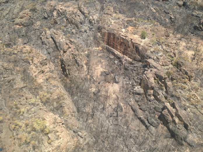
|
|||||
1:20:48 PM |
On 24/01/2014 kieranl wrote: >Parks photo of Summer Day Valley post-fires > Shit. At least I'll miss the tree if I ever do Rats Tail again. |
| There are 82 messages in this topic. |
Home | Guide | Gallery | Tech Tips | Articles | Reviews | Dictionary | Forum | Links | About | Search
Chockstone Photography | Landscape Photography Australia | Australian Landscape Photography | Landscape Photos Australia
Please read the full disclaimer before using any information contained on these pages.
Australian Panoramic |
Australian Coast |
Australian Mountains |
Australian Countryside |
Australian Waterfalls |
Australian Lakes |
Australian Cities |
Australian Macro |
Australian Wildlife
Landscape Photo |
Landscape Photography |
Landscape Photography Australia |
Fine Art Photography |
Wilderness Photography |
Nature Photo |
Australian Landscape Photo |
Stock Photography Australia |
Landscape Photos |
Panoramic Photos |
Panoramic Photography Australia |
Australian Landscape Photography |
High Country Mountain Huts |
Mothers Day Gifts |
Gifts for Mothers Day |
Mothers Day Gift Ideas |
Ideas for Mothers Day |
Wedding Gift Ideas |
Christmas Gift Ideas |
Fathers Day Gifts |
Gifts for Fathers Day |
Fathers Day Gift Ideas |
Ideas for Fathers Day |
Landscape Prints |
Landscape Poster |
Limited Edition Prints |
Panoramic Photo |
Buy Posters |
Poster Prints